Ground Control Points in Surveying

Ground Control Points in Surveying
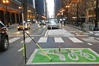
When surveying land, it is important to establish baseline points and ground control points (GCPs). The purpose of a GCP is to help with alignment and accuracy when recording data. Establishing GCPs can be done manually or through equipment like lasers. When establishing manual GCPs, it is important to consider the surrounding environment - wind speed, direction, and sun angle are all factors that need consideration.
When surveying land, it is important to establish baseline points and ground control points (GCPs). The purpose of a GCP is to help with alignment and accuracy when recording data.
When surveying land, it is important to establish baseline points and ground control points (GCPs). The purpose of a GCP is to help with alignment and accuracy when recording data. Baseline points are typically placed at known distances apart in order to create an accurate map of the area. GCPs may be further used as reference points when drawing lines on the map or compass while heading out into unknown territory. By establishing these points beforehand, you will have a better idea where you are located and can make more accurate measurements without extra hassle.
Establishing GCPs can be done manually or through equipment like lasers. When establishing manual GCPs, it is important to consider the surrounding environment - wind speed, direction, and sun angle are all factors that need consideration.
Ground Control Points (GCPs) are essential in surveying and land management. When establishing GCPs, it is important to consider the surrounding environment - wind speed, direction, and sun angle are all factors that need consideration. Depending on your equipment and project goals, you may choose to establish GCPs using manual or automated means.
• Image Orthorectification • LiDAR and 3D Models • UAV based Sensors • Airport Mapping Databases • Surface Elevation Mapping • Sensor Calibration • Driverless Vehicle Navigation • Planimetric (GIS) Mapping • Urban Planning / Engineering • Utility Mapping CompassData. Inc. | Ground Control Points Per ISO and FAA Certified Quality Processes, CompassData strives to meet and exceed the customers project requirements: • GCP survey planned to capture best suited feature types (photo-identifiable with contrast, permanent, and flat features) • Accuracy tailored to end-product accuracy requirements • Digital pictures of the GCP location from each cardinal direction • Image chip showing GCP location • Field Station Diagram (sketch) • ESRI ARCGIS shapefile and Google Earth KML • Coordinate file containing Lat/Long and Elevation with data converted to the desired spatial reference and coordinate system • Post processing Accuracy Report GCPs: Essential Foundation for Geospatial Accuracy | Ground Control Points Create Accurate Data Safety • Efficiency • Accountability CompassData is the world’s leader in providing GCP data for aerial photogrammetry, drone imagery, remotely sensed data by satellites and other GIS applications. CompassData has decades of field experience and ISO certified processes ensuring the accuracy, currency and standard format. download this map for FREE – see on back how CompassData’s Excellence: Over 60,000 Archive GCPs available “Our mission is to map the world – We take that seriously!” – CompassData, Control Freaks CompassData 7074 S Revere Parkway Centennial CO 80112 U.S.A. COMPASSDATAINC.COM CompassData Logo are trademarks or registered trademarks of CompassData and are used underlicense. © 2020 CompassData Inc. All rights reserved. CompassData, Inc. |Ground Control Points When is Submeter Accuracy Required? With the growing constellation of commercial earthobservation satellites, there has been an explosion of spatial data in our everyday lives. Once the realm of surveyors and rocket scientists, Global Positioning Satellite (GPS or GNSS) technology is now in our automobiles, wrist watches, and cell phones, and is becoming increasingly tied to data, be it a satellite image of the earth or the map location of the restaurant we just made reservations with while stuck in traffic. How does the satellite image and internet map display the restaurant within meters of its real location? GCPs. GCPs were used to geolocate the satellite image and the map that digitized from the image and displayed in the application. The positional accuracy will become even more critical as we enter the age of driverless vehicles. Standards and Expertise Simple in application but complicated to survey, post process, and delivery consistent to ISO 9001 and DO-200 (FAA) quality standards. It starts with planning and logistics to get a surveyor in place to collect GNSS satellite data. GCP feature selection by the field data collector is critical experience of field staff makes the difference. A good GCP is also usable for all scales of imager, from 1-inch pixels to 1-meter pixels. The ideal GCP is collect on a welldefined angle of a large, high-contrast feature that lasts permanently. How are GCPs created and used for? Ground Control Points (GCPs) are points on the ground which are generally photo-identifiable, e.g. a sidewalk corner or concrete pad, that have been surveyed with a GNSS receiver in the field. Using geodetic processing methods the coordinates result in an accuracy of centimeters of their true location. Without ground control, accuracies for nonorthorectified, satellite images are typically 10-200 meters off, aerial imagery by single meters and models from the drone flights would be distorted. Remotely sensed imagery and Lidar data can be georeferenced to also centimeters of accuracy with GCPs. RSGCP ™ : Remotely Sensed GCP In remote or denied areas CompassData produces Remotely Sensed Ground Control Points (RSGCP ™) of less than or equal to 1-meter guaranteed. CompassData offers (RSGCP ™), providing control for those areas that are restricted, too remote, or too dangerous for field data collection. Download the World’s Largest Commercially Available Ground Control Point Archive https://www.compassdatainc.com/groundcontrol-points-archive/

Comments
Post a Comment